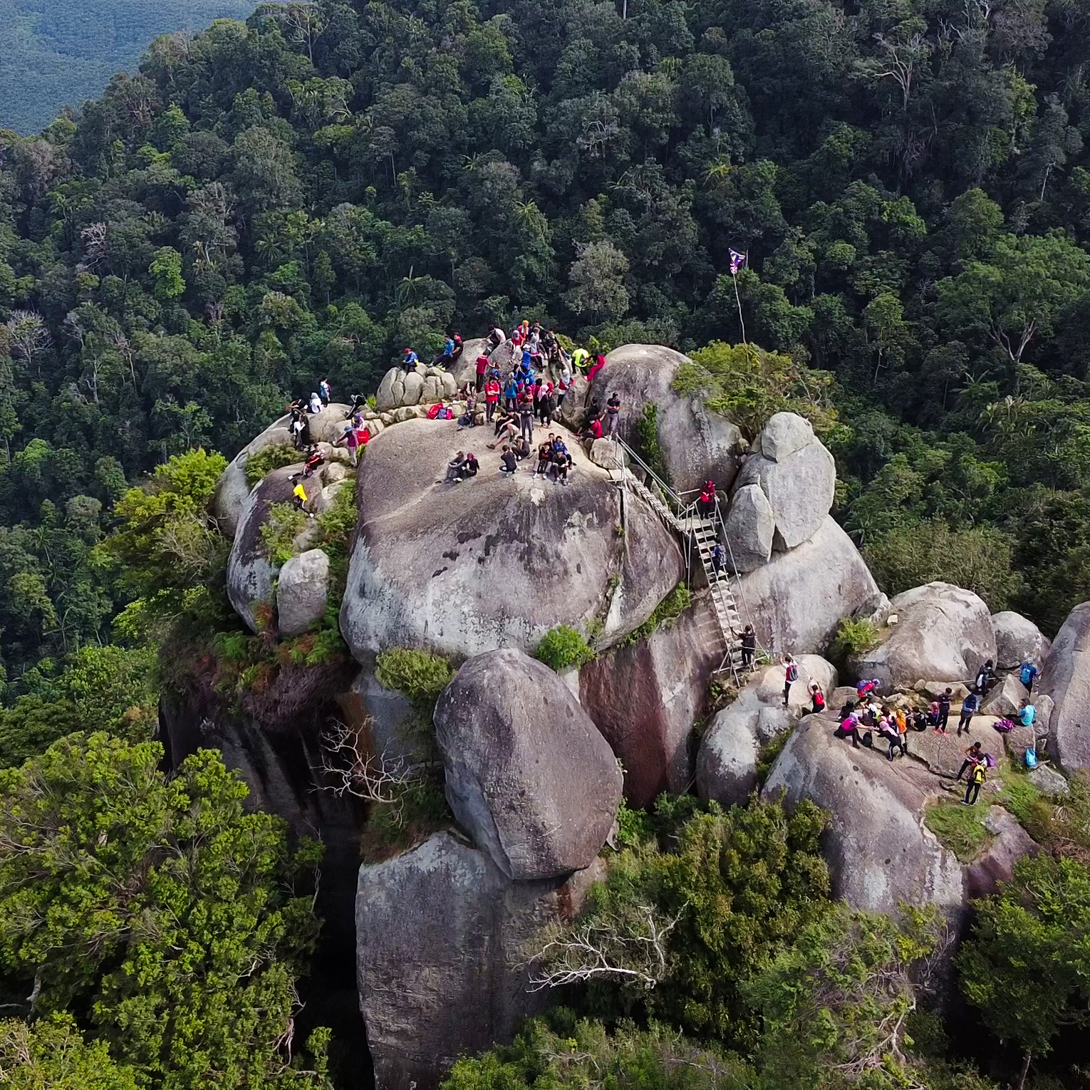
A shaded forest climb from Ulu Bendul recreational park, a popular beginner summit.Pendakian hutan teduh dari taman rekreasi Ulu Bendul, puncak pemula popular.
📏
DistanceJarak
8 km return
⛰️
ElevationKetinggian
825 m
⏱️
TimeMasa
4 to 5 hours
🎟️
EntryMasuk
Permit at the park
📅
Best timeMasa terbaik
Dry mornings
Gunung Angsi is a friendly introduction to peninsular peaks, climbed from the Ulu Bendul recreational park near Seremban. The trail is mostly shaded jungle with a steady gradient and a couple of steeper sections near the top.
It is a good weekend target for hikers building up from Broga toward bigger mountains, with a forested summit and a real sense of achievement for a half-day effort.
Gunung Angsi ialah pengenalan mesra kepada puncak semenanjung, didaki dari taman rekreasi Ulu Bendul berhampiran Seremban. Denai kebanyakannya hutan teduh dengan kecerunan tetap dan beberapa bahagian curam berhampiran puncak.
Ia sasaran hujung minggu yang baik untuk pendaki yang meningkat dari Broga ke gunung lebih besar, dengan puncak berhutan dan rasa pencapaian sebenar.
Trail highlightsTarikan denai
✓Shaded jungle trailDenai hutan teduh
✓Good beginner summitPuncak pemula yang baik
✓Starts at a recreational parkBermula di taman rekreasi
✓Cool forest streamsSungai hutan sejuk
Facilities & what to expectKemudahan & apa dijangka
Parking at Ulu Bendul park
Toilets & picnic area
Register before hiking
Shaded jungle
Routes up Gunung AngsiLaluan mendaki Gunung Angsi
Gunung Angsi can be climbed by more than one route. Pick the one that suits your fitness and time.Gunung Angsi boleh didaki melalui lebih daripada satu laluan. Pilih yang sesuai dengan kecergasan dan masa anda.
Ulu Bendul Route
Moderate
The popular route from the Ulu Bendul recreational park near Seremban.Laluan popular dari taman rekreasi Ulu Bendul berhampiran Seremban.
📏 8 km return⏱️ 4 to 5 hr
Bukit Putus Route
Moderate to hard
A steeper alternative from the old Bukit Putus road, quieter but less marked.Alternatif lebih curam dari jalan lama Bukit Putus, lebih tenang tetapi kurang bertanda.
📏 ~7 km return⏱️ 4 to 5 hr
Trailheads, markings and access can change. Check locally or hike with a guide if you are unsure of the route.Permulaan denai, tanda dan akses boleh berubah. Semak setempat atau mendaki dengan pemandu jika tidak pasti.
Topographic map centred on the trailhead. Zoom in to see the contours and the footpaths mapped by OpenStreetMap.Peta topografi berpusat di permulaan denai. Zum masuk untuk melihat kontur dan denai yang dipetakan OpenStreetMap.
🚗 Drive cost from KLKos memandu dari KL
What it costs to drive to the trailheadKos memandu ke permulaan denai
DistanceJarak
70 km
Petrol (one way)Petrol (sehala)
RM11
Return tripPergi balik
RM22
Petrol only, estimated for a typical sedan at 8 L/100km and today's RON95 price (RM1.99/L). Tolls vary by route.Petrol sahaja, dianggarkan untuk sedan biasa pada 8 L/100km dan harga RON95 hari ini (RM1.99/L). Tol berbeza mengikut laluan.
Drive about 70 km south to the Ulu Bendul recreational park on the Seremban to Kuala Pilah road. Park and register there before starting the marked trail up.Pandu kira-kira 70 km ke selatan ke taman rekreasi Ulu Bendul di jalan Seremban ke Kuala Pilah. Letak kereta dan daftar di sana sebelum mula denai bertanda.
🎒 What to bringApa nak bawa
•2 litres of water2 liter air
•SnacksSnek
•Grippy shoesKasut bertapak baik
•Rain layerLapisan hujan
💡 Hiking tips & safetyTip & keselamatan mendaki
1Start in the morning so you are back before the common afternoon showers.Mula pada waktu pagi supaya kembali sebelum hujan petang biasa.
2The park at the base has facilities, so it is an easy spot for families to wait.Taman di pangkalan ada kemudahan, jadi tempat mudah untuk keluarga menunggu.
3Follow the main marked route, as a few side trails branch off along the way.Ikut laluan utama bertanda, kerana beberapa denai sisi bercabang.
🛏️ Stay near Gunung AngsiMenginap berhampiran Gunung Angsi
Doing an early start or making a weekend of it? Find a place to stay near Seremban and compare live rates.Mula awal atau jadikan hujung minggu? Cari tempat menginap berhampiran Seremban dan bandingkan harga terkini.
Booking links compare live rates across sites; we may earn a commission at no extra cost to you.Pautan tempahan membandingkan kadar terkini; kami mungkin memperoleh komisen tanpa kos tambahan kepada anda.
How hard is Gunung Angsi?Berapa sukar Gunung Angsi?
It is a moderate half-day hike, harder than Broga but easier than Gunung Nuang. It suits hikers with some experience and reasonable fitness.Ia pendakian sederhana separuh hari, lebih sukar daripada Broga tetapi lebih mudah daripada Gunung Nuang. Ia sesuai untuk pendaki berpengalaman dan cergas.
Where does the Gunung Angsi trail start?Di mana denai Gunung Angsi bermula?
The most popular route starts at the Ulu Bendul recreational park near Seremban, where you register and park before the climb.Laluan paling popular bermula di taman rekreasi Ulu Bendul berhampiran Seremban, tempat anda daftar dan letak kereta sebelum mendaki.
 MyFuelCost