A muddy, magical mossy-forest climb above Cameron Highlands.Pendakian hutan lumut berlumpur yang ajaib di atas Cameron Highlands.
📏
DistanceJarak
6 km return
⛰️
ElevationKetinggian
2,110 m
⏱️
TimeMasa
5 to 6 hours
🎟️
EntryMasuk
Guide required
📅
Best timeMasa terbaik
Dry mornings
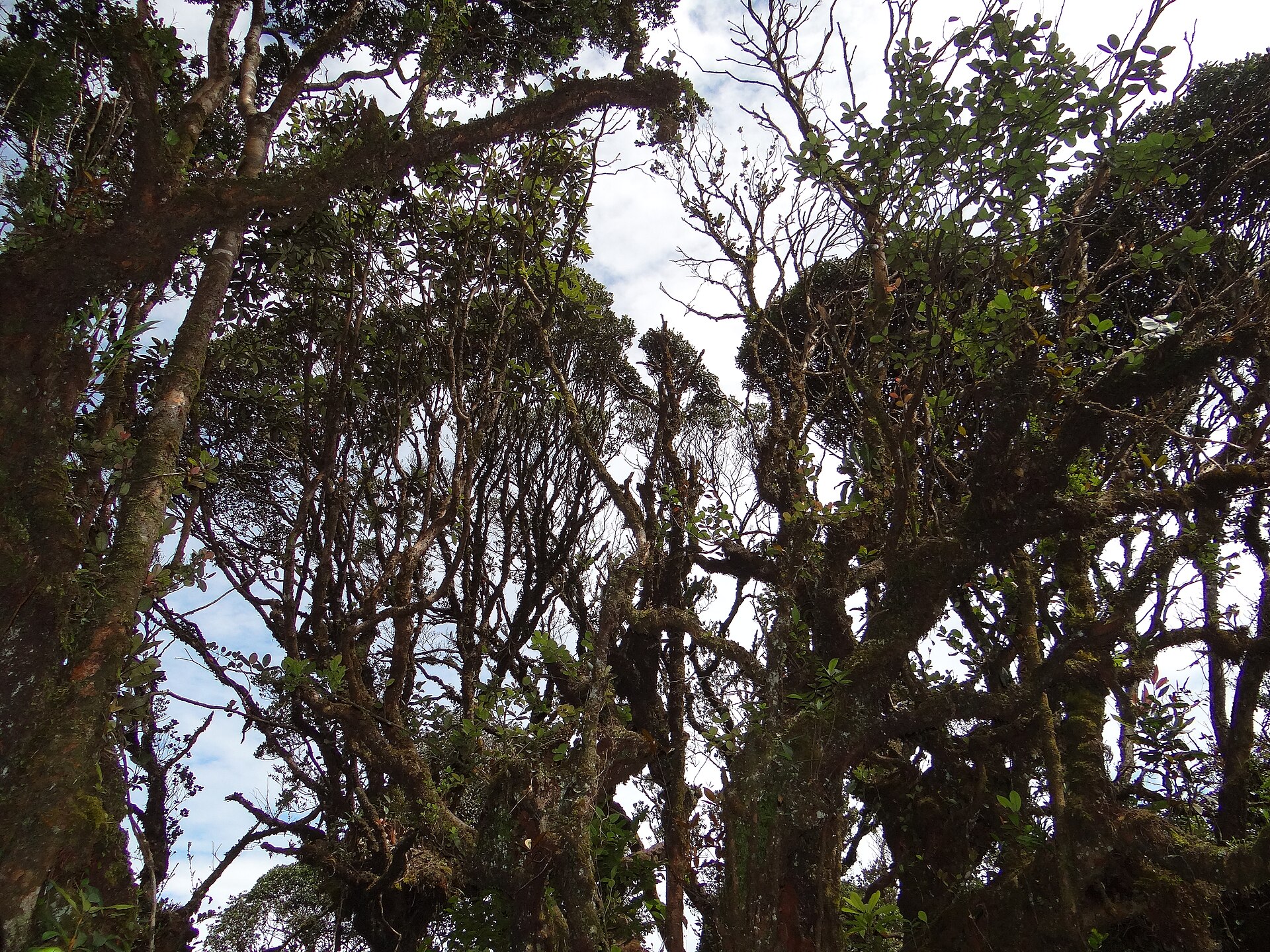
Gunung Irau begins at the Mossy Forest above Cameron Highlands and climbs through one of the most atmospheric forests in the country: gnarled, moss-draped trees, tangled roots and near-constant mist. It is short in distance but slow and muddy, with lots of clambering over roots.
At over 2,000 m the air is cold and the ground is often wet all year, so it feels wilder than its length suggests. A guide is required and keeps you on the fragile route.
Gunung Irau bermula di Hutan Lumut di atas Cameron Highlands dan mendaki melalui salah satu hutan paling beratmosfera di negara ini: pokok berlumut, akar berbelit dan kabus hampir berterusan. Ia pendek jaraknya tetapi perlahan dan berlumpur.
Pada lebih 2,000 m udara sejuk dan tanah selalunya basah sepanjang tahun, jadi ia terasa lebih liar daripada panjangnya. Pemandu diperlukan dan memastikan anda di laluan rapuh.
✓Paired with a Cameron tripDigabung dengan lawatan Cameron
Facilities & what to expectKemudahan & apa dijangka
Parking at Mossy Forest
No toilets on trail
Guide required
Very muddy year-round
Routes up Gunung IrauLaluan mendaki Gunung Irau
Gunung Irau can be climbed by more than one route. Pick the one that suits your fitness and time.Gunung Irau boleh didaki melalui lebih daripada satu laluan. Pilih yang sesuai dengan kecergasan dan masa anda.
Mossy Forest Route (Gunung Brinchang)
Hard
The single guided route from the Mossy Forest, muddy and root-tangled throughout.Laluan berpandu tunggal dari Hutan Lumut, berlumpur dan berakar sepanjang jalan.
📏 6 km return⏱️ 5 to 6 hr
Trailheads, markings and access can change. Check locally or hike with a guide if you are unsure of the route.Permulaan denai, tanda dan akses boleh berubah. Semak setempat atau mendaki dengan pemandu jika tidak pasti.
Topographic map centred on the trailhead. Zoom in to see the contours and the footpaths mapped by OpenStreetMap.Peta topografi berpusat di permulaan denai. Zum masuk untuk melihat kontur dan denai yang dipetakan OpenStreetMap.
🎟️ Book aheadTempah awal
Guided hikes & tours near Gunung IrauPendakian berpandu & lawatan berhampiran Gunung Irau
Guided treks, day tours and tickets in the area, with prices in MYR. Often easier and cheaper booked online.Pendakian berpandu, lawatan sehari dan tiket di kawasan ini, harga dalam MYR. Selalunya lebih mudah dan murah ditempah dalam talian.
🚗 Drive cost from KLKos memandu dari KL
What it costs to drive to the trailheadKos memandu ke permulaan denai
DistanceJarak
200 km
Petrol (one way)Petrol (sehala)
RM32
Return tripPergi balik
RM64
Petrol only, estimated for a typical sedan at 8 L/100km and today's RON95 price (RM1.99/L). Tolls vary by route.Petrol sahaja, dianggarkan untuk sedan biasa pada 8 L/100km dan harga RON95 hari ini (RM1.99/L). Tol berbeza mengikut laluan.
The trail starts at the Mossy Forest near Gunung Brinchang, above Brinchang in Cameron Highlands, about 200 km from KL. You arrange a guide who meets you at the Mossy Forest entrance.Denai bermula di Hutan Lumut berhampiran Gunung Brinchang, di atas Brinchang di Cameron Highlands, kira-kira 200 km dari KL. Anda atur pemandu yang bertemu di pintu masuk Hutan Lumut.
🎒 What to bringApa nak bawa
•Warm and waterproof layersLapisan panas dan kalis air
•Gloves for the rootsSarung tangan untuk akar
•2 litres of water2 liter air
•Shoes you do not mind ruining in mudKasut yang anda tidak kisah rosak dalam lumpur
💡 Hiking tips & safetyTip & keselamatan mendaki
1Expect deep mud all year, so waterproof shoes and a spare pair of socks help a lot.Jangkakan lumpur dalam sepanjang tahun, jadi kasut kalis air dan stokin ganti banyak membantu.
2It is cold and misty up top, so bring a warm layer even though you are in Malaysia.Ia sejuk dan berkabus di atas, jadi bawa lapisan panas walaupun di Malaysia.
3Combine it with a Cameron Highlands weekend to make the long drive worthwhile.Gabungkan dengan hujung minggu Cameron Highlands untuk menjadikan pemanduan panjang berbaloi.
🛏️ Stay near Gunung IrauMenginap berhampiran Gunung Irau
Doing an early start or making a weekend of it? Find a place to stay near Cameron Highlands and compare live rates.Mula awal atau jadikan hujung minggu? Cari tempat menginap berhampiran Cameron Highlands dan bandingkan harga terkini.
Booking links compare live rates across sites; we may earn a commission at no extra cost to you.Pautan tempahan membandingkan kadar terkini; kami mungkin memperoleh komisen tanpa kos tambahan kepada anda.
Why is Gunung Irau so muddy?Kenapa Gunung Irau sangat berlumpur?
It runs through a high-altitude mossy cloud forest that holds moisture all year, so the ground stays wet and muddy even in dry spells. Waterproof shoes are essential.Ia melalui hutan awan berlumut altitud tinggi yang menyimpan lembapan sepanjang tahun, jadi tanah kekal basah walaupun musim kering. Kasut kalis air penting.
Do I need a guide for Gunung Irau?Perlukah pemandu untuk Gunung Irau?
Yes, a guide is required. It protects the fragile mossy forest and keeps you on the correct, easy-to-lose route through the roots and mist.Ya, pemandu diperlukan. Ia melindungi hutan lumut yang rapuh dan memastikan anda di laluan betul yang mudah hilang.
Photo: Adam Jones from Kelowna, BC, Canada (CC BY-SA 2.0)
 MyFuelCost